
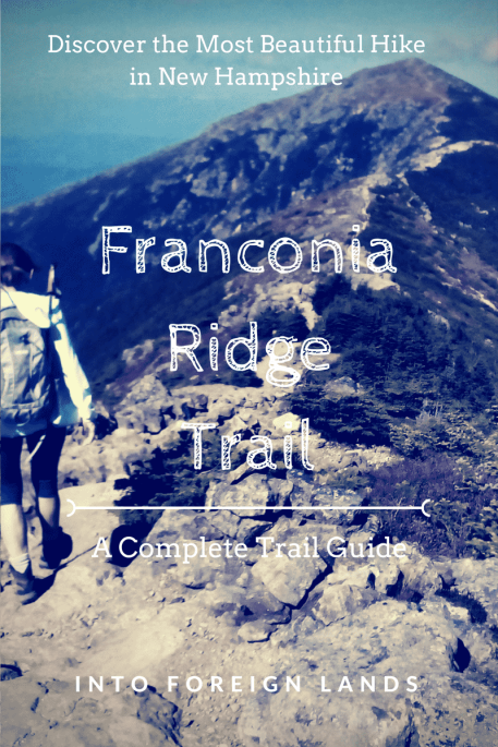
Visit New England and you’ll face one unavoidable truth: the Appalachian Mountains just aren’t that big. This might lead you to assume that hiking in New Hampshire is easy. Yet if you assumed this, you would be wrong. Trails in New Hampshire are some of the toughest I’ve ever encountered. Most especially, one of the best hikes in New Hampshire: the Franconia Ridge Trail.
There is something special about hiking in New Hampshire. I love the way the forest changes as you ascend up the mountains, going from leafy green deciduous trees; to pine forests; to sparse, high alpine environments with little cover and excellent views. Once you enter the mountains in New Hampshire, you are transported to another world.
Few places are as good for that as the Franconia Ridge Trail in the White Mountains.
All About the Franconia Ridge Trail
Before I get ahead of myself and start gushing all about how much I love this trail. Let’s just go over some of the fine print.
The Franconia Ridge Trail traverses the Franconia Ridge (surprising, I know) from Mt. Flume at the southern end, all the way up to Mt. Lafayette to the north. In between the two peaks, it summits Mt. Liberty, Little Haystack Mountain, and Mt. Lincoln. The section from Mt. Liberty to Mt. Lafayette is also included in the storied Appalachian Trail.
Possibly the most interesting aspect of this trail, apart from the views, is the biodiversity. From Mt. Flume to Little Haystack, the trail passes through pine forests typical of New Hampshire. In here, it smells like Christmas and the air is blanketed with silence. From the peak of Mt. Haystack, the trail emerges into a high alpine environment where low shrubs and lichen reign supreme. This is an exceedingly delicate environment. Though small, many of these plants take years if not decades to grow. But it’s not all doom and gloom up here. Not only are the plants quiet fragile; they are also quite short. This means more views for us hikers.
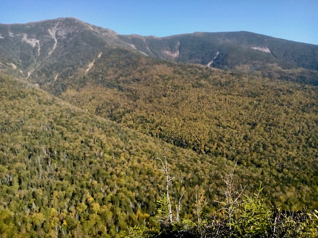
The views from the top of Franconia Ridge are breathtaking. To the east, you can look down into the remote Pemigawasset Wilderness and across to the rolling peaks of the Bondcliff Trail. To the north, you’ll see the rest of Franconia ridge rising above you. And to the west sit the Kinsman and Canon ranges, as well as the steep cliffs of Franconia Notch, former home of the Old Man in the Mountain. (RIP)
The tricky thing about the Franconia Ridge Trail is that it never intersects with a road or parking area. Given that it sits on the top of one of the highest ridges in New Hampshire, that kind of makes sense. So for us intrepid hikers hoping to best this trail in a single day, we face a small problem: in order to enjoy this hike, we must first ascend to it.
A word of caution before we keep going: because the Franconia Ridge Trail is high and exposed, it can be particularly dangerous during harsh weather conditions. Up there, hikers are prone to lightning strikes and at the mercy of strong winds. The weather in the White Mountains is highly changeable so be sure to check reports before hiking. If you see clouds coming into the ridge, better to delay your hike until another day.
Hiking Franconia Ridge Trail as a Day Hike: Planning the Trip
When my mom recently had the idea to spend a weekend on the trails, I knew I wanted to tackle the best hike in New Hampshire: my beloved Franconia Ridge Trail. The only problem was, I’d never done it as a day hike before.
Usually, I include the Franconia Ridge Trail as part of the Pemigawasset Loop, a 2 to 4-day backpacking journey that combines the Franconia Ridge with the Bond Ridge for a truly epic experience. But mom wasn’t game for a camping trip, so it’d have to be a day hike.
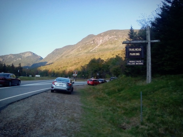
Luckily, there was an obvious loop that began and ended at a parking lot off of the Franconia Notch Parkway called Lafayette Place.
We’d hike up the Falling Waters Trail (because I suppose Waterfall Trail was just too obvious) for three miles to the peak of Little Haystack Mountain. From there, follow Franconia Ridge trail for 1.7 miles to the peak of Lafayette. Then hike down Greenleaf Trail to the Greenleaf Hut (open May to October), and finally, down the Old Bridle Path for 2.8 miles and back to our car.
Great. I had the whole day planned.
Before we get into the meat of this post, I need to talk about my boots.
Prior to this trip, the soles of my hiking boots had started to fall off. They were old boots and I knew I ought to get them resoled but I was unorganized and didn’t. In lieu of a cobbler, I bought something called “Shoe Goo” at REI and tried to glue the soles of my boots back onto my boots.
And up until the morning of our Franconia Ridge hike, it seemed to have worked.
Just to be safe, I used some duct tape to secure the heels. I considered bringing the duct tape with me, but the glue seemed secure and I didn’t want to add the weight to my day pack. I left the tape at home and we headed for the mountains.
Hiking the Best Hike in New Hampshire: Our Epic Day on the Franconia Ridge Trail
Given that this would be a long day, hiking 9 miles through tough New Hampshire terrain, we wanted to get started bright and early.
So, of course, we arrived at the trailhead at 10am. Oh well.
Mom had convinced herself and, reluctantly, me that we ought to hike up the Old Bridle Path and back down the Falling Waters trail. I thought it was a bad idea but the guidebook suggested it so that was what mom wanted to do. Thankfully, there were some Park Rangers at the trailhead there to convince my mom that indeed we ought to hike UP the Falling Waters trail and come down the Bridle Path. NOT the other way around. Good.
For those following along at home, the Falling Waters Trail is by far the steeper of the two. If you’re going to tackle this loop as a day hike, I highly recommend ascending via the Falling Waters Trail. Old Bridle Path makes for a lovely descent.
Part 1: Falling Waters Trail
So it began. We headed up the three-mile Falling Waters Trail. The trail starts off as a meandering path through deciduous forests. Maple, beech, and oak trees grow thickly on the lower slopes of the mountain and the trail ascends slowly, following the path of a small brook.
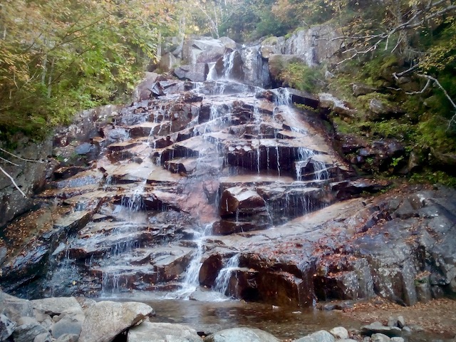
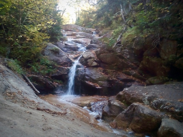
After perhaps a mile of hiking, maybe a bit more, we reached the first waterfall. It featured large granite slabs with water gushing over the crest and a massive group of college kids clambering all over it. I don’t have a photo of that one.
Somewhere in between falls number one and two, we hit our first obstacle of the day. Remember how I had used “shoe goo” to glue my boots together? Remember how I said they seemed fine?
I was wrong.
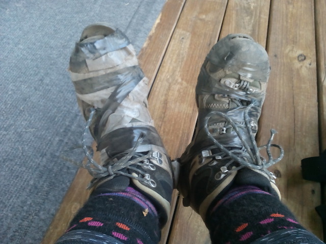
As I climbed up a large granite boulder, I felt something catch underneath my foot. Looking down, I was dismayed to find that I was standing on the toe of my sole. In fact, the toe had detached itself and curled backward underneath my foot. The heel and mid-section were still in place.
Good thing I brought that duct tape… Oh, no, I left that duct tape at home. The only adhesive I had with me was the box of overlarge bandaids I’d brought to tape up the growing blister on the back of my right heel.
Sorry blister. I used the band-aids to secure the sole to the toe of my boot. And it worked. For a time.
From here, the trail began to get a bit steeper but nothing too crazy. A little bit of boulder scrambling, but that’s to be expected in New Hampshire. The second and third waterfalls followed in quick succession. Both were excellent specimens. Taller than the first, the water cascaded down ladders of granite with pine and maple trees growing out of the sides.
Somewhere in this section, the toe of my other boot decided that it didn’t want to live anymore. Taking out two more band-aids, I secured the offending article. But the boots were wet and the band-aids didn’t want to play. I needed another solution. Something that would force the sole of my boot to stay attached to my foot. I removed my hair elastic from my hair and used it to secure the toe.
It worked. But it also meant I would spend the rest of the day hiking with my long hair down, drenched in sweat, and clinging to my neck, cheeks, forehead, and eyes. What’s a girl to do?
Not too long after the third waterfall, the trail begins to ascend quickly through a series of switchbacks. If you’re imagining the type of smooth, graded switchbacks that characterize most hiking everywhere else on the planet, you’d be wrong. This is New Hampshire. Our switchbacks feature scrambling up boulders and jumping from one massive granite slab to the next.
Finally, just below the summit, as the pines were starting to thin and we hesitantly said out loud to each other, “I think we might be almost there” the trail took a sharp turn in the direction of outer space and climbed directly up the mountain all the way to the summit.
Out of breath, sweating, and shielding our eyes from the harsh sunlight above the treeline, we reached the top of Little Haystack Mountain. I turned around to take in the view and immediately my heart stopped in my chest.
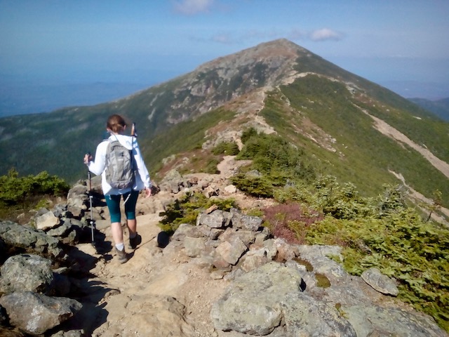
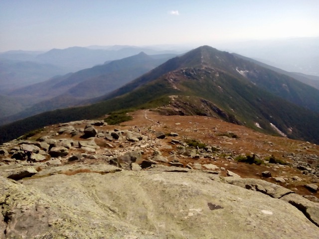
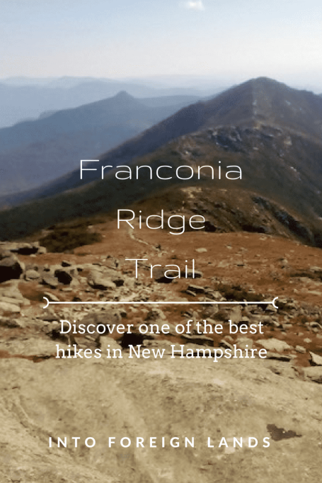
The valley swept away far, far below me. The granite wall of Franconia Notch opened up to the north. Turning my eyes to follow the trail, I saw a dusty brown line cutting across the top of a dramatic ridge, leading up to the peak of Mt. Lincoln.
We had reached the Franconia Ridge Trail.
Part 2: Hiking 1.7 miles of the Franconia Ridge Trail
The top of Little Haystack is comprised mainly of large flat slabs of granite scattered everywhere like so many marbles. We chose a likely looking spot to have a rest and a snack before tackling the ridge.
A word of caution: it was very windy up there. As long as we were hiking, I was perfectly comfortable in my t-shirt and leggings. But as soon as we sat down, I needed my jacket.
I guess the good thing about the wind was that it dried out my sweaty, disgusting hair.
From Little Haystack, the trail dropped down into the saddle before heading up to Mt. Lincoln. There is a small rise in the middle of the saddle, really quite tiny, and then the trail ascends steeply up to the summit of Lincoln at 5,089 feet. From here, the trail is visible all the way to Lafayette.
From Mt. Lincoln the trail drops somewhat steeply down to the saddle where there is another hump and then a small grove of low-lying pine trees. If you are ever unlucky enough to be caught up on the ridge in a storm, this is the best spot to take cover.
The final ascent, though not as steep as the ascent to Lincoln, is slightly longer, and by this point, my legs were pretty tired. The trail also gets a little difficult to follow. You’re not going to accidentally walk off the mountain or anything, but try to keep your eyes open for the white blaze of the Appalachian Trail marker. This is a sensitive environment and erosion is a big issue. Stepping off of the path has wider implications than meet the eye.
The top of Lafayette is glorious. Franconia Notch is below you to the west. Garfield Mountain rises to the north and seemingly all of the Appalachian Mountains stretch away in many different directions. At 5,260m, this is one of the tallest peaks in New Hampshire and the absolute tallest in the Franconia Notch area. For this reason alone, this is one of the best hikes in New Hampshire.
This was also the highest point of the hike. It was all downhill from here.
Part 3: Greenleaf Trail to Greenleaf Hut or the Death of Megan’s Boots
It was beautiful on top of Lafayette but still very windy and I didn’t much fancy trying to make sure my sandwich didn’t fly away while I ate it. Mom and I decided to postpone our lunch until we reached the relative shelter of the Greenleaf Hut.
Going into the descent we both felt pretty optimistic. The hard part was over, the hut was only a mile away, and the trail didn’t look particularly challenging.
But it’s right when you start to feel comfortable that it all goes to shite, amirite?
Not even a quarter of a mile into the descent, I tripped, catching something under my right foot. I look down, and the sole of my shoe, freed from the confines of its band-aid restraints, had completely detached itself from my foot. Indeed, the sole of my boot was on its own. Follow its own manifest destiny. It was flying solo. It was rogue one.
And I’m out of band-aids. Well, shit.
I grab my troublesome sole and shove it into my backpack.
For those of you who are curious, hiking down a steep mountain covered in slippery granite boulders in a shoe that has absolutely no traction is about as fun as you’d think it would be. It’s terrible.
Still, I’m a trooper and I’ve been through worse. I pushed on, hoping that if I got to the hut I could find something that would hold my boots together at least for the rest of the hike.
Boot issue aside, the hike down from Lafayette to the Greenleaf Hut was enjoyably scenic. It’s fairly exposed for the first half mile or so, then it begins to wind in and out of some low pine forests. Just before the hut, the trail dips down into a small valley by a pond.
It was about here that the sole politely removed itself from my second boot. I assume it didn’t want to be left out of this bid for freedom by sole number one.
I gazed up at the Hut above it. It was my only hope.
As soon as I reached the hut, I started chatting with an Irish couple we’d run into on the ridge. I showed them my boots. Full of concern, they reached into their bag and pulled out a roll of scotch tape. I wasn’t sure it would hold up but thought it was better than nothing. She very kindly told me to keep it, just in case. I thanked her profoundly and ducked inside.
The hut was packed. All the groups of college kids and campers were milling about, getting some snacks and replenishing their drinking water. For those who don’t know, these huts are kind of like rudimentary mountain hotels. They are run by an organization called AMC (Appalachian Mountain Club) and offer beds, hot meals, snacks, some supplies, and running water. Reservations are most definitely needed if you want a bed but if you just need somewhere to take a break, you’re very welcome. The huts are open usually from May to October.
I sat down at an open table and started taping up my boots.
“Having boot problems?” I heard from across the table. I looked up and a guy sitting further down had noticed my desperate attempts to reconnect my boot with its sole.
“I think I have some electrical tape if you’d rather use that?”
I accepted. If not duct tape, electrical tape was the next best thing. He handed me a brand new roll of tape and told me to keep it, just in case.
That, my friends, is trail magic.
Part 4: The Old Bridle Path Home
With my boots now fixed up, mom and I downed our wet, soggy, and unbelievably delicious sandwiches and headed out to finish the hike. A sign inside the hut warned that it would take another 2 hours and 40 minutes to reach the bottom. That seemed a bit rich to me, the trail was only 2.8 miles from here! But who was I to second guess the sign?
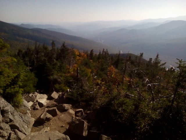
Going down from the hut, the trail follows a ridge, with some exposed sections of trail offering gorgeous lookouts back up at Franconia Ridge. Steep in places, it was nowhere near as steep as the Falling Waters Trail from this morning.
After just a little under two hours, mom and I had made it back down to the parking lot. We had sore feet but full hearts. We gratefully hopped back into the car and drove back to our condo where warm showers and clean clothes awaited us.
Best Hike in New Hampshire: Franconia Ridge Trail with Falling Waters and Bridle Path At-A-Glance
- Total Distance: 8.9 miles
- Falling Waters Trail: 3.2 miles
- Franconia Ridge Trail: 1.7 miles
- Greenleaf Trail: 1.1 miles
- Old Bridle Path: 2.9 miles
- Total Time: 6 – 8 Hours
- Highest Point: Mt. Lafayette, 5,260ft (1,600m)
- Lowest Point: Lafayette Place Trailhead: 1,900ft (580m)
How to get there: From Lincoln, New Hampshire, drive north on Interstate 93 for about 7 miles until the Lafayette Place Trailhead and Campground exit. Parking is on the right. If the lot is full, parking is available on the street or on the other side of the road. U-turns are not possible on the highway, next exit is 3 miles further north on I-93/Rt. 3.
Like this post? Pin it!


Loved your description of the forest. Makes me want to go and breathe in that fresh piney air!
LikeLike
I have never been to New Hampshire and I had no idea there was so much hiking to be done! The scenery looks totally breathtaking.
LikeLike
Trail magic is a fabulous thing! I’ve just finished reading an account of the full AT journey (AWOL on the Appalachian Trail) and I recall him saying that this was one of the most exposed sections. Looks like a brilliant hike, and I’m glad you didn’t have to slither around too much for the rest of your day.
LikeLike
I would love to thru-hike the Appalachian Trail! It is definitely on my wish list, when I get enough time. I think that this ridge and another one, the Presidential Range, just to the north, are the most exposed.
LikeLike
Oh, I’d LOVE to do some hikes in New Hampshire! I grew up in Maine and hiking and camping were an integral part of my childhood. I’ve driven through the White Mountains but never hiked there. Love your description of hiking up those peaks….Love the mountains and forests in New England!
LikeLike
You should absolutely hike the Whites, they are incredible. I grew up in Massachusetts so while the forests are my home, I didn’t get into hiking till I became an adult. Better late than never though, because New England hiking is awesome. Hopefully I’ll get to Maine soon!
LikeLike
So, you had me at “it smells like Christmas” 🙂 This looks like an awesome hike – I’m definitely saving this post so I can plan my own trip there! Side note: I now carry a small roll of duct tape with me at all times for this exact reason. I’ve been bit too many times by unexpected “breakdowns” when traveling or on the trail! Glad you persevered 🙂
LikeLike
Yep! Definitely carrying duct tape from now on! Glad the post inspired you, it’s truly an amazing place.
LikeLike
It looks like an amazing hike. So glad you were able to get some tape for your boots. That must have been stressful!
LikeLike
Sounds like a right adventure! Great read, thanks
LikeLike